Welcome, Autel Pilots!
Join our free Autel drone community today!
Join Us

NTRIP RTK mountpoints question

curd1

Member
Joined
Jan 28, 2022
Messages
7
Reaction score
3
Age
43
Hi folks. I checked with my DOT for info on the NTRIP network and they gave me a login and a list of mountpoints. They said "check with your equipment supplier for the proper mountpoint"
I checked with my vendor, who in turn checked with Autel support. They got back to me and told me to "use the closest one"
From the list of mountpoints I was given, they appear to have differing Data Formats/ Adjustments/ Geoid models. I cannot find info on Geographic location.
Can anyone give some advice on mountpoints or even a good reference for me to read?
thank you
Curt
 
You're kind of talking about two different things- the datastream vs the location that corrections are being sent from.

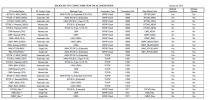
Mountpoint is the datastream- essentially different formats of the RTCM NTRIP corrections. Below is an example from Indiana.

Within the mountpoints, you sometimes have an option to choose the closest CORS location; or you could use automatic setting; or a VRS (virtual reference station) type correction where you're essentially getting corrections from multiple CORS locations.

Assuming your DOT has similar mountpoints, you'll want one of the RTCM options that hopefully includes multiple constellations (beyond GPS). Disregard "CMR" options, because these are the Trimble format.

So in the Indiana example, I'd try the RTCM3_MAX mountpoint, and if that doesn't work, RTCM3_NEAR, and if that doesn't work choose a single site.

I don't actually have my EVO II yet- but just went through this setting up my survey rovers for a project in Indiana.

Let us know if it works out for your EVO.

1649169736895.png
 
  • Like
Reactions: curd1
Thanks for your reply. That is quite the table. I live in Wisconsin and have not been able to find such detailed info. The DOT provided me with a list of 7 Mountpoints via an email and also listed the satellite network they reference (GPS/ Glonass/ Gallileo). Minnesota provides much more information, including the Adjustment (date) and Recommended Geoid Model. I am not a Professional Land Surveyor, I am just trying to get the best out of my drone for modeling in Reality Capture. I have used a RTCM3Net mountpoint in the past and saw the accuracy value go to 1-3 cm, so I assume I was getting about the best accuracy I could hope for. But at the same time I wonder if I should be considering some of the other RTCMxxx networks on the list. And I'd rather not have to try each one in the field until I am connected- is there a way to know which one to use when planning a mission? Or, as you suggest, is a little trial and error part of it connecting?
thanks again
 
I'm also in WI- they have been changing the mountpoints recently. I usually use RTCM3Net, but it has been problematic lately. I think RTCM32 or RTCM3 works well.
 
  • Like
Reactions: curd1
I'm also in WI- they have been changing the mountpoints recently. I usually use RTCM3Net, but it has been problematic lately. I think RTCM32 or RTCM3 works well.
good to know. thanks!
 

Latest threads

Members online

Forum statistics

Threads
11,229
Messages
102,663
Members
9,821
Latest member
Bigmaxsg