You are using an out of date browser. It may not display this or other websites correctly.
You should upgrade or use an alternative browser.
You should upgrade or use an alternative browser.
Raptor Maps for 640T
- Thread starter jmason702
- Start date
I lightly looked at it. I never did inquire into pricing due to the fact that I have a full time job and really cannot devote the time to get a large solar contract and fulfill it the way I would want to.
If it works like they shop it, it does seem like they have AI to do a lot of the anomaly spotting and reporting.
Do you have any idea on pricing? It seems like this would be great if you contracts for multiple large solar fields. It seems like it would save a large amount of time.
If it works like they shop it, it does seem like they have AI to do a lot of the anomaly spotting and reporting.
Do you have any idea on pricing? It seems like this would be great if you contracts for multiple large solar fields. It seems like it would save a large amount of time.
Hi Jeff,
After connecting with our @Drones team, we will not be able to support the 640T or 640R at this point. The Autel Evo II Dual 640 R imagery is lacking some metadata that our platform relies upon and we can only use this imagery for smaller sites, on a case-by-case basis, until further notice. We recommend acquiring one of our documented drone solutions.
Please let us know if you have any further questions.
Thank you,
WOW.......... got this back today from Raptor Maps.
Jordan Van Roe
8:03 AM (6 hours ago)
to me, Alex, Drones
Hi Jeff,
After connecting with our @Drones team, we will not be able to support the 640T or 640R at this point. The Autel Evo II Dual 640 R imagery is lacking some metadata that our platform relies upon and we can only use this imagery for smaller sites, on a case-by-case basis, until further notice. We recommend acquiring one of our documented drone solutions.
Please let us know if you have any further questions.
Thank you,
Trying to figure out what mapping software will work with Autels Thermal Drones at ALL.................................
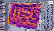
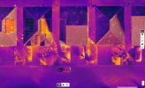
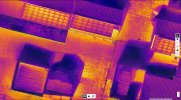
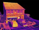
I think I am going to stick with the 640T as I cant map using the thermal JPEGs and produce a HIGH quality thermal RGB map, then select certain photos for inspection using the IRPCTool.
Examples attached
That is one awesome advantage the 640T has over the others is straight-up JPEGs along with two other files types for radiometric data, that can be processed accurately through the IRPCTool...
Examples attached
That is one awesome advantage the 640T has over the others is straight-up JPEGs along with two other files types for radiometric data, that can be processed accurately through the IRPCTool...
Attachments
| Tue, Apr 5, 3:01 PM (23 hours ago) | |||
|
What metadata is lacking, please? I can discuss this with Autel and see if there can be a firmware update on this.
Thank you
�
Hi Jeff,
Our team has been in contact with Autel and we have identified that the lacking metadata is gimbal specific in that the yaw, pitch and roll data is not currently stored in the imagery metadata. Autel plans to add those fields to their next firmware release. The current timeline for the release is unclear but we are hoping the issue is resolved by the end of Q2.
Thank you,
I hope all this info is helpful to the community, the DJI advanced is NOT the drone for sure as they limit the crap out of it, but Autel is getting a bad wrap onto getting in the game but looks as if that might change, all the emails and the other stuff all of us can push out will change things for sure, please help any way you can...
wfish
Active Member
I am in the same boat and have had extensive conversations with Autel, Raptor Maps and Scopito (GRC) about using their respective platforms for the analysis of large solar panel inspections. At the moment the 640T is not a viable option for large scale solar panel inspections that need the service of such platforms as Raptor Maps and Scopito. As a result, I have been giving much consideration about replacing my 640T with the 640R, however, after reading this thread...it sounds like the 640R is not an option. I am very surprised to hear about this, especially since it's a flir sensor and outputs to rjpeg. If this is the case then it appears that our only option is to switch to the Mavic 2 Advanced Enterprise or to a more expensive non-Autel option.
At one point in my communication with Autel and Scopito, I was hopeful that they were close to providing a solution, but that was a few months ago and have not heard a word, since.
For now, I will keep my 640T Enterprise (the images are awesome) and focus more on flat roof inspections, residential solar panel inspections and create thermal maps using Agisoft Metashape when necessary.
Well if you could contact Autel about if they are going to update the gimble info into the meta data.
Here is the thing, DJI is not USA made. DJI is not FLIR. If Autel can get the 640R in the game, it will be the best one to have all around. You agree?
Here is the thing, DJI is not USA made. DJI is not FLIR. If Autel can get the 640R in the game, it will be the best one to have all around. You agree?
wfish
Active Member
Correct about DJI not being made in the US and is not a Flir sensor, but it is support by Raptor Maps and to the best of my knowledge supported by Scopito. Yes, I would agree that the 640R is the way to go for Autel.Well if you could contact Autel about if they are going to update the gimble info into the meta data.
Here is the thing, DJI is not USA made. DJI is not FLIR. If Autel can get the 640R in the game, it will be the best one to have all around. You agree?
wfish
Active Member
The file output for the 640T is problematic for platforms such as Raptor Maps and Scopito, until these issues have been resolved the 640T will not be compatible with such services.Also what do they tell you is wrong with the 640T? the file types? If so can those be changed by Autel?
Please list the issues you were told about the 640T
Similar threads
- Replies
- 0
- Views
- 705
- Replies
- 0
- Views
- 551
- Replies
- 5
- Views
- 1K
Latest threads
-
-
-
Seeking Recommendations for Custom Voiceover Solutions
- Started by nobes
- Replies: 1
-
We need your Autel evo 2 V1 6K rugged bundle.
- Started by Autel-euducational
- Replies: 1
-
Questions on original Evo 1 and the new app Autel Sky
- Started by jaja6009
- Replies: 0


