

- Joined
- Oct 24, 2020
- Messages
- 9
- Reaction score
- 5
- Age
- 53
Hi,
I searched and read very many useful posts but I can't find a clear answer. Apologies if it's there, I will then delete my post.
I'm a beginner and had fun flying shortly a Evo 2 pro 6k for the first time. The aircraft flew fine and responded ok to stick inputs. I managed to take off and land it where I wanted.
But I would please require help with 2 questions:
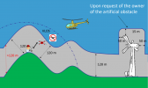
a) I read in multiple posts that altitude is reported incorrectly in the controller and the app while flying. I felt that was the case for me too. Even considering I was in a slightly inclined open field (and height is measured vs. the starting point), the indicated altitude was maybe 50% lower than the real one (i hovered the Evo a couple of times and observed this evident gap). How can I respect the oncoming European rules which prescribe a max altitude of 120m at any time/point vs. ground (not vs starting point) if the data I have is 50% off? Please see picture that clarifies the rule.
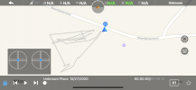
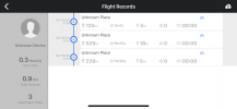
b) Back home I looked at the flight logs in the Autel app and could not understand much (i enclose 2 pictures, the list of the 3 short flights and 1 log): I was all the time in the same spot and the starting point altitude is wildly different in the 3 records. Could someone tell me why/ what i did wrong?
thanks a lot!
Conditions at flight
- 2.5.11 firmware
- IMU, compass, gimbal all calibrated with OK feedback
- all done in novice mode
- accurate landing ON
- no warnings during flight
- village about 500 mt (1640 ft) above sea level
- 14 satellites locked (GPS bar 3 out of 4)
- nice weather, 12 celsius, little to no wind, middle of countryside, no antennas or magnetic fields
I searched and read very many useful posts but I can't find a clear answer. Apologies if it's there, I will then delete my post.
I'm a beginner and had fun flying shortly a Evo 2 pro 6k for the first time. The aircraft flew fine and responded ok to stick inputs. I managed to take off and land it where I wanted.
But I would please require help with 2 questions:
a) I read in multiple posts that altitude is reported incorrectly in the controller and the app while flying. I felt that was the case for me too. Even considering I was in a slightly inclined open field (and height is measured vs. the starting point), the indicated altitude was maybe 50% lower than the real one (i hovered the Evo a couple of times and observed this evident gap). How can I respect the oncoming European rules which prescribe a max altitude of 120m at any time/point vs. ground (not vs starting point) if the data I have is 50% off? Please see picture that clarifies the rule.
b) Back home I looked at the flight logs in the Autel app and could not understand much (i enclose 2 pictures, the list of the 3 short flights and 1 log): I was all the time in the same spot and the starting point altitude is wildly different in the 3 records. Could someone tell me why/ what i did wrong?
thanks a lot!
Conditions at flight
- 2.5.11 firmware
- IMU, compass, gimbal all calibrated with OK feedback
- all done in novice mode
- accurate landing ON
- no warnings during flight
- village about 500 mt (1640 ft) above sea level
- 14 satellites locked (GPS bar 3 out of 4)
- nice weather, 12 celsius, little to no wind, middle of countryside, no antennas or magnetic fields
Attachments
Last edited:


