Now THAT is what I am talking about! You deserve a gold medal for this test and putting this together. Seriously. Really impressive stuff.
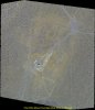
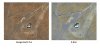
I am going to give your instructions a go and see if I can replicate it to the quality level that you did for your test (I suspect so, those instructions you wrote are A+ in quality and detail). Your result is much better quality imagery than Google Earth so I really do believe this is viable. And better than ESRI too... they get their imagery from DigtalGlobe and a few other sources so it's incredible that the XSP easily surpasses what they provide. So much potential here, as I think you'd agree.
Some questions:
How long did it take to go from Step 1 to the last step in your instructions?
Is it a fairly easy process to set up the waypoints using the method that you described or is there some trial and error? Also, with some practice, would it be possible to do this whole process out in the field on a tablet or smartphone if someone wanted additional orthomosaic imagery on the spot?
Did the XSP handle all of this smoothly when you conducted the mission? What happens if you include the photos when the drone turns, does the resulting map get warped?
I'll probably think of more questions when I go to sleep lol, of course...
It's a bit concerning that the GPS error tolerance is that high so I hope they listened to your suggestion for improvement (maybe it's a part of the new firmware? I didn't see anything about that in the new firmware notes, but hey you never know). I tend to geofit images using ArcMap and some object that is close by, so using it for a project near something recognizable still is doable, but yeah I agree that would be a big upgrade if they fixed that.
I agree, this 100% looks doable.
Thanks for your kind words, I've learned a great deal from the generous and helpful folks on this and other forums, and am always glad to make my own contribution when I can.
As for your questions, the most time consuming part of this whole operation was tracking down the camera lens and sensor specifications. Why they aren't included in the published specs I don't really know, but between a fair amount of research and some back-and-forth communication with Autel CS, I was able to get them nailed down so I could input the required information into the Maps Made Easy template. With that information, most of the steps take longer to write down than to actually perform. The actual processing time will vary depending on the MME workload (free jobs will always get bumped by paying jobs), but I believe it took less than 2 hours from the time I uploaded the files until processing was complete, and they sent status reports with updated completion time estimates throughout the process.
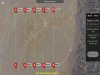
I find it extremely easy to set and manipulate the waypoints, just make sure you get the desired AGL entered for each one. There should be no problem doing it the field, but I would highly recommend a tablet rather than a phone just to have the extra workspace. I have used an iPad Air and an iPad Pro, both 9.7", and found that it is much easier and more precise to drag the waypoints into place using a stylus rather than my finger.
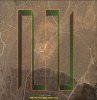
One thing I might mention, although I'm pretty sure it's been well documented on this and other forums, is that Starlink's 1600' distance limit on waypoints is measured from the first waypoint set, not your launch position. If you're having trouble fitting your site inside the limits of the safety circle, set a "dummy" waypoint for your first waypoint in the center of your project, then build your mission plan as normal - in other words, Waypoint 2 would be at the lower left corner of your flight plan. As long as you're launching from a point somewhere inside the circle, you can theoretically have a flight line up to 3200' long.
The X-Star worked flawlessly on this project. Since I selected "Return to Home" as the behavior once the mission was complete, the flight was about as close to being totally autonomous as possible. My main error was confusion over when I started the camera firing; as I approached the first waypoint I didn't realize I had already started shooting, so I inadvertently turned it off when I thought I was turning it on and wound up missing a portion of the first flight line before I got myself squared away. Totally my fault, and if I had taken a look at the flight record in the field I would have seen the results of that mistake at the time and reflown the mission while I was still on site. One of the many things you just learn by experience! Make sure you shoot in JPEG format so the images are geotagged. I have my controller mounted on a tripod (as a surveyor, feels very natural to me), so I just gently rotated it to keep it more or less pointed at the XSP throughout the mission, and had no issues with video or RC connectivity.
I don't know what happens if you don't delete the photos in the turns, this is the only project I've had processed and I took them out before uploading to MME. I would guess it would distort the image or possibly generate an error message, but I really don't know for sure.
Agreed, as long as you have some known objects present to geofit the image, you can use ArcMap or AutoCAD to simple move the image into position. Still, it would be handy if the precision of the EXIF data matched that of the XSP's GPS. Thanks again, be sure to let me know if you have any other questions - this is a great place to learn from each other!


") . I'm sure that other people have the same questions that I do and would benefit since there isn't much info out there of how to do this, specifically for an Autel drone. Not that it's necessarily rocket science, but it doesn't seem as intuitive as having a third party app that allows you to just automate a lot of this away. Maybe that will change at some point once a third party developer creates an app that does that for Autel (?).
. I'm sure that other people have the same questions that I do and would benefit since there isn't much info out there of how to do this, specifically for an Autel drone. Not that it's necessarily rocket science, but it doesn't seem as intuitive as having a third party app that allows you to just automate a lot of this away. Maybe that will change at some point once a third party developer creates an app that does that for Autel (?).