Welcome, Autel Pilots!
Join our free Autel drone community today!
Join Us

Maps Made Easy - Photos Don’t Contain Altitude Values - Best Beginner Mapping Software?

Dfly

Active Member
Joined
Feb 21, 2021
Messages
33
Reaction score
12
I hope this isn’t glaringly obvious elsewhere, as I couldn’t find any similar posts…

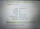
I’m trying to break into the mapping realm and Maps Made Easy seems like the most cost effective way to start right now. I’ve flown my E2P on missions using the native Autel Explorer mission planning and loaded the images on the MME site. When they check a sample image for all the necessary EXIF data, it shows no values in the altitude fields. Is this normal for all Autels? Is this going to limit functionality in what I can put together and market to potential clients?

Does anyone have much experience using their Evo II with MME?

In 2022, is Drone Deploy or Reality Capture a cost-effective alternative to the pay as you go method with MME? I’m also looking for relative ease of use for a beginner.

Again, I’m just breaking in and want to see what I can offer in terms of the basics, i.e. 2D orthomosaic maps. Maybe move into 3D (though MME has limited 3D creation, from what I understand, with limits on how oblique your camera angle can be), and may consider adding GCPs later, with more experience.

Thanks for any input,

JP
 
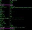
Evo2 Pro/Enterprise tags photos with coordinates. Maps Made Easy can process them. Can you share an image?

There is no less expensive processing platform unless you want to go with OpenDroneMap. Relality Capture is also a pay as you go application but involves more knowledge to operate. MME is somewhat limited in what you can do, but it is the easiest to work with.
 
Thanks Dave. I figured MME was going to be the best option for me right now.

I have made a previous ortho and recall those images also lacked the relative altitude, and thus the estimated GSD. The final result seemed to turn out ok, so I didn’t think much of this message. Now that I’m trying out some more and seeing this unknown altitude, I’m wondering if this is limiting the potential of the final product available to me.

On another note, I’m trying it out with some snow cover to see how bad it really is with snow in the image. They say with snow cover, you can only make “flat maps” with 10-15% overlap, and that workflow is DJI-specific. I’m trying out their classic workflow to see if you can still make a map with snow cover if there’s a decent amount of structure in each image. If it doesn’t work, it looks like offering any basic mapping in the winter up here in MN is out of the question.

I tried contacting MME for answers, but they don’t seem too keen to respond to anything.
image.jpg
 
Maps Made Easy doesn't display anything for XMP estimated GSD with DJI craft either. It comes up with it's own value. As far as the relative altitude, I don't know why it is not pulling that info because it is available. But, MME processing is not really good at giving you precise elevation data anyway. Your MME map should show good "relative" elevation differential but not absolute elevation accuracy.

I've posted the question about why MME is not seeing the altitude data in the image exif and I'll report what they have to say. But, as said, your MME map is only going to show good relative elevations even if it reads the altitude from images. If showing "real" global elevations is important to you, you can input the ortho.tif and/or the dem.tif into QGIS and adjust the entire surface to better reflect reality.
 
  • Like
Reactions: drrags
I've posted the question about why MME is not seeing the altitude data in the image exif and I'll report what they have to say.
You can read their explanation HERE.

In short, Autel doesn't write a "relative" altitude value to the image exif/xmp data and that is what MME is looking for. But your MME map should still process just fine.
 
You can read their explanation HERE.

In short, Autel doesn't write a "relative" altitude value to the image exif/xmp data and that is what MME is looking for. But your MME map should still process just fine.
Hey, thanks for digging into it!

So it sounds like, with good relative accuracy and elevation changes, I should be able to come up with volumetric estimates for piles of fill, etc, right? And, if I get to a point where I need absolute accuracy, including elevations, GCPs would also take care of that, correct?

Sorry for the rookie questions!
 
So it sounds like, with good relative accuracy and elevation changes, I should be able to come up with volumetric estimates for piles of fill, etc, right?
Correct.

And, if I get to a point where I need absolute accuracy, including elevations, GCPs would also take care of that, correct?
Yes. With the caveat that MME is not the tool when or if you move to needing to align surface modeling to coordinate systems. Their "GCP workflow" is meant to help your maps align better with online map tiles and also subsequent layers of your own map. It can't be used to align your model with a state plane grid, for example. But you should take your time and do a lot of research before you go down that road. MME is a good place to start though.
 
  • Like
Reactions: Dfly
Much appreciated! My head is spinning a little less now, and take my time, I sure will!
 
  • Like
Reactions: Dave Pitman

Latest threads

Members online

Forum statistics

Threads
11,280
Messages
102,948
Members
9,878
Latest member
Elio-Italy