Welcome, Autel Pilots!
Join our free Autel drone community today!
Join Us

Drone Loss

andrew124C41

Well-Known Member
Joined
Jul 22, 2022
Messages
118
Reaction score
31
Age
72
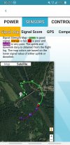
I was flying a smart orbit at 360 feet of a bridge crossing between MD and VA from a boat ramp on the VA side. All was well until the drone suddenly lost signal. I could not control it. It deviated from the orbit and it may have hit trees... Not sure. When it lost signal it should have gone Home. It didn't. It was only 1700 feet away. I have had it half a mile away with excellent signal.

Any idea what happened?
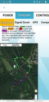
Screenshot_20230414-062757_Airdata UAV.jpgScreenshot_20230414-063021_Airdata UAV.jpg
 
Your flight path looks like when it crossed the river, your LOS might have been obstructed by the tree line closest to you. That would explain the signal loss. Don't know about your RTH settings on the autonomous mission.
 
Your flight path looks like when it crossed the river, your LOS might have been obstructed by the tree line closest to you. That would explain the signal loss. Don't know about your RTH settings on the autonomous mission.
I was able to see the drone. It was above the trees. It was am intelligent mode not mission and should have RTH per specs.
 
I was able to see the drone. It was above the trees. It was am intelligent mode not mission and should have RTH per specs.

I agree with @Dave Pitman looks like a signal loss to me; what was your RTH altitude set to? The minute you lost the signal, did you try to gain altitude manually? Also, it is possible there is a bug when flying an intelligent mode combined with signal loss that prevents RTH from working as expected.

I never use intelligent modes or missions; always manual. If signal loss occurs, the video feed usually cuts out first, so I immediately press the left stick all the way forward to gain altitude until the signal comes back; usually that works and RTH is not triggered. I think in the 2+ yrs I've had the EVO, RTH has only been triggered once and I cancelled it as soon as it was controllable again.

As my EVO (and batteries) age, I take fewer and fewer chances with it, no more flying for personal reasons (it only leaves the ground for paying jobs), and I am very careful with preventing signal loss or battery failures.
At this point, I am a recreational pilot. I will show you the info from Air Data. I was not able to regain control at all. It was programed for 400 foot RTH. My so called smart orbit should have cleared the trees in the other side of the bridge. But, when it lost signal which was strange because I could see the drone from the edge of the boat ramp, it just kept going and the altitude was not high enough to clear the mountain.

Home was in the parking lot of the boat ramp. However, I was controlling the drone from the edge of the ramp where I had VLOS.

I had planned to stop the orbit before I would lose VLOS which was about three quarters of the orbit. But I lost signal while looking at the drone at the midpoint of the bridge... The red marker... and then it went purple.

I have now heard from others that there is a problem with RTH while in intelligent modes.

This brings me to a question. This was a really large orbit around a bridge. While I have practiced orbiting manually, I never tried something so large! How would you have done it manually. See attached photos.

The Google Earth is where it wound up.

Screenshot_20230414-062757_Airdata UAV.jpg
Screenshot_20230414-063021_Airdata UAV.jpgScreenshot_20230414-121237_Earth.jpg
 
Last edited:
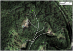
I looked at the map closer and it looks like it is at the end of a road on the side of the hill.. worth taking a short drive over to take a look?
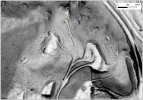
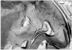
I "enhanced" the topography data and there seems to be a trail leading almost directly to the last known coordinate you show above..W

1681514898321.png
1681514760983.png
 

Attachments

  • 1681514719111.png
    1681514719111.png
    893.2 KB · Views: 4
  • Like
Reactions: EBEPLS
I looked at the map closer and it looks like it is at the end of a road on the side of the hill.. worth taking a short drive over to take a look?
I "enhanced" the topography data and there seems to be a trail leading almost directly to the last known coordinate you show above..W

View attachment 15967
View attachment 15966
Wow, thank you. I drove up to the house with the pool. The guy said he looked for it but could not find it and he did not want me to look because he said there are steep drop-offs. I hope he didn't find and keep it. Are these roads or trails? Can I drive?

If it rains tonight or tomorrow though. And, I think it will probably be quite damaged. It was going 20 mph....at least that is what it was supposed to be doing.
 
I don't know the condition of the pathway.. but there is one that leads almost directly to the last known point.

This is the approximate google maps link: 39°16'03.7"N 77°32'49.8"W
If you have Avenza Maps on your phone or tablet you can load up the PDF below and it will display your location over the PDF map once you are close.

Geo-PDF: Evo2ProLost.pdf
 
At this point, I am a recreational pilot. I will show you the info from Air Data. I was not able to regain control at all. It was programed for 400 foot RTH. My so called smart orbit should have cleared the trees in the other side of the bridge. But, when it lost signal which was strange because I could see the drone from the edge of the boat ramp, it just kept going and the altitude was not high enough to clear the mountain.

Home was in the parking lot of the boat ramp. However, I was controlling the drone from the edge of the ramp where I had VLOS.

I had planned to stop the orbit before I would lose VLOS which was about three quarters of the orbit. But I lost signal while looking at the drone at the midpoint of the bridge... The red marker... and then it went purple.

I have now heard from others that there is a problem with RTH while in intelligent modes.

This brings me to a question. This was a really large orbit around a bridge. While I have practiced orbiting manually, I never tried something so large! How would you have done it manually. See attached photos.

The Google Earth is where it wound up.

That sounds exactly like I thought, possibly a RTH bug when using an intelligent mode. Not sure what the bug is (stop and hover, RTH too low, RTH in the wrong direction, take off towards China?) but it does sound like that combination is not a good one. That is very unfortunate; TBH if you are flying recreationally, and mostly in rural areas with no controlled airspace around then DJI is going to be the better bet. DJI's software is better and they have less bugs. Autel's sole claim to fame is no geofencing; but their software is years behind and it is quite buggy.


I film massive orbits/arcs all the time, the parallax effect and speed ramping large orbits/arcs is one of my favorite ways to introduce the viewer to an aerial view of the project. Less than an hour ago I just finished an orbit at night of a 4 mile long bridge using 100% manual control so it can definitely be done.

The big secret to manually orbiting literally anything is to turn on the central cross hairs. With them on, pick a spot on the target and place the crosshairs on that spot. If you can keep those crosshairs on that central spot for the entire arc/orbit then it will look smooth in post. This works no matter how big or small the object is.

For the 4 mile long bridge, I just picked a lit column at the center of the bridge, then started the orbit, fortunately it was not windy and the drone performed perfectly throughout the maneuver. It is actually easier to orbit bigger objects vs smaller ones. The larger the object the faster you can go; once you are orbiting an object that is so large that full right or left rudder still seems slow; that's when it is easiest because you no longer have to try to keep a constant speed, you just keep giving it wide open throttle and keep the crosshairs centered; then in post you use speed ramps to speed it up and keyframes to correct drifting if you did not manage to keep it perfectly centered.
 
Last edited:
  • Like
Reactions: uas_gian
As my EVO (and batteries) age, I take fewer and fewer chances with it, no more flying for personal reasons (it only leaves the ground for paying jobs), and I am very careful with preventing signal loss or battery failures.
Question: do you have any idea how long batteries typically last? Eg how many flights?
 
I was flying a smart orbit at 360 feet of a bridge crossing between MD and VA from a boat ramp on the VA side. All was well until the drone suddenly lost signal. I could not control it. It deviated from the orbit and it may have hit trees... Not sure. When it lost signal it should have gone Home. It didn't. It was only 1700 feet away. I have had it half a mile away with excellent signal.

Any idea what happened?

View attachment 15956View attachment 15957
I have the EVO 2 Pro V2 with the Smart Controller V2 and the Alien Tech range extender. I have about $5,000.00 Canadian invested in this setup.

This might sound like closing the gate after the horse got out but I have the Marco Polo recovery system. I can hop in my car and drive in the direction I think it is in, pickup a signal right away and within a mile or so of the drone and it will take you within six feet of your drone wherever it is. No subscription on the gps tracker.

A must have when you have a lot invested. Good luck with finding it Andrew. Hope you are successsful............Dale.
 
Question: do you have any idea how long batteries typically last? Eg how many flights?

There are a ton of factors that affect that and below are some of them, but a general rule of thumb is 2yrs or 200 cycles (charges/discharges) whichever comes first. There are outliers of course, some people have reported up to 5yrs and some have reported as few as 60 cycles but the average is 2yrs or 200 cycles. Here is a decent article that talks about their lifespan but I still think they are a bit optimistic in their numbers. The hardware engineer from Intel quoted in the article says almost the same thing I said.

Factors that affect battery life (specifically for drones):
  • Storage - this I would say is the number 1 factor that affects your battery life. If they are stored completely drained or always stored fully charged you will be lucky to make it to 100 cycles or one year since batteries are not being used far more than they are powering the drone.
  • Charging process - The last 20min or so of a multi-cell LiPo battery's charging process is a balancing cycle, if you skip that too many times (i.e. take it off the charger when the last light is flashing), you will greatly shorten the life of the battery and possibly lose the drone in flight do a catastrophic drop in voltage mid flight.
  • Temperature - Trying to recharge a LiPo while it is hot is a sure way to shorten its life, also flying when a LiPo is too cold is a sure way to lose the battery and the drone. Storage temperature of course affects them as well. You should never store them in say an outdoor shed or an un-airconditioned building.
  • Handling - LiPos are very sensitive to drops, one drop might seem minor but that one drop from 3' onto cement could have shortened its life or cause it to fail prematurely.
As you can see there is no real way to know how long your actual LiPos will last, if it helps at all I can tell you that I am now at the 2yr 4mo mark with my EVO II Pro and all of my batteries still work and they all still show 33min of flight time remaining at takeoff. No idea how many cycles I have though since I've never bothered to check. But I have followed all of my own advice above to extend their longevity.

Keep in mind though that my use case is a little unique, since I don't fly recreationally, my typical drone flight is less than 5-10min to get the few seconds of aerial footage that I need for the project. I do think mine will probably last 3-4yrs but who knows....I will certainly report back here when they start swelling or failing to charge. So far I have been having better luck with Autel's batteries than I did with DJI's P4P and the Mavic Pro; their batteries were so bad towards the end that they would swell within 1yr and 60 cycles no matter how careful I was.
 
I hadn't heard of the Marco Polo recovery system, thanks for mentioning it, I just looked it up.
I wonder how useful a recovery system would be, if you can't get close to the drone before it crashes. As I see it, the main goal is to keep the drone from crashing or falling out of the sky, because recovering a drone after that occurs would seem of questionable value. I'd expect most would be a total loss, after crashing.
And in many flights (and generally all my flights) I am flying in an area I've walked into, and am not near my car to use to quickly drive over to where the drone MIGHT be still up in the air.
BTW a note on forum software: I had originally clicked "reply" on one post, then decided not to reply to that one but to a different one, yet I was unable to get the first "reply" out of this post. I even closed the tab on my browser to close the forum page, but when I opened it again the first reply box was still there and it seems there is no way to remove it.
I had the Marco Polo system for a couple of years and used it twice so I sold it. Another, maybe better, way to track a fallen drone is to always run a screen record while you're flying so you have a way to see where it went down. Even if the drone is a total loss, you can at least retrieve the SD card and maybe sell parts from the drone on ebay. I see others doing this now which is a good thing since Autel doesn't sell parts.

The forum will save a post in memory unless you highlight and delete it.
 
I was flying a smart orbit
I was flying a smart orbit ... Any idea what happened?
View attachment 15956

Well to me the straight line from points F to H is mysterious. This looks more like drift. Meaning the drone couldn't hold position and the wind pushed it south, or some sensor told the drone there is an obstacle to be avoided. But the straight line is more likely due to a lost GPS signal or a failing compass. If just the controller would have lost its connection, this should not cause any drift.

The interesting fact is, after point H it seems to resume the programmed orbit, only with an offset center of the circle. To me that's a second indication to that the compass or gps data were causing errors. The aircraft must have still had a connection to the remote as it was sending coordinates, but the data sent might have been false. On a real lost connection to the pilot RTH would have started.

For me this would have been a scenario of disconnecting USB and immediate rebooting the controller as stand alone, while trying to get closer to the aircraft.
 
Last edited:
Well to me the straight line from points F to H is mysterious. This looks more like drift. Meaning the drone couldn't hold position and the wind pushed it south, or some sensor told the drone there is an obstacle to be avoided. But the straight line is more likely due to a lost GPS signal or a failing compass. If just the controller would have lost its connection, this should not cause any drift.

The interesting fact is, after point H it seems to resume the programmed orbit, only with an offset center of the circle. To me that's a second indication to that the compass or gps data were causing errors. The aircraft must have still had a connection to the remote as it was sending coordinates, but the data sent might have been false. On a real lost connection to the pilot RTH would have started.

For me this would have been a scenario of disconnecting USB and immediate rebooting the controller as stand alone, while trying to get closer to the aircraft.
Thanks for your input. I am relatively new at this. I think about 30 hours much of it just practice. I did not have time to think. It was orbiting at 20 mph. I actually was just about to stop the orbit and bring it back because I was going to lose line of sight. But this happened before I could do something. The drone had been functioning flawlessly. As you can see, according to Air Data graph, I never lost GPS signal. The drone would just not respond. By the time I rebooted...had I even thought of that, it would have crashed. I have State Farm insurance as a recreational pilot and they should cut me a check for the full price of the aircraft.

My question is what will Autel do? It is still under warranty.
 
In the interest of providing follow up, State Farm honored the policy and reimbursed me for the drone.

I still have not heard anything from Autel about the loss on the ticket number they provided.
 
  • Like
Reactions: DanielD
Question: do you have any idea how long batteries typically last? Eg how many flights?
I was told that LiPo cells age differently based on temperature and frequency of charging. So there is no golden rule about their age vs performance, more over age vs safety. This goes for any LiPo type battery pack, such as those in Drones today.

One way to approach is, when drone batteries have been recharged 100 times expect problems. This would mean stop using them in the air after 80 recharges. For commercial use it requires us to keep a separate log for each battery, even if the software seems to do so, we have a paper copy as well. Batteries are labeled and numbered to backtrack the usage and circumstances.

The side note to this approach is, if a battery pack is not used for a long time (more than 2 months) or was left in hot places, e.g. in the trunk of a car under direct sunlight, or if the battery pack was left in too cold places, this affects the prediction of it's safety.

Often people claim, their recently bought battery failed unexpectedly. If you read further they didn't follow those basic rules about storing them in safe places and refresh charging once every 2 or 3 months.

I personally stop using a battery pack if it was left in a too hot place for too long. A battery that was left too cold, can be revived but should not be used for flight immediately. In that case just drain it on the ground and then recharge to full in a warmer place.
 

Latest threads

Members online

No members online now.

Forum statistics

Threads
11,284
Messages
103,000
Members
9,892
Latest member
hakles