Welcome, Autel Pilots!
Join our free Autel drone community today!
Join Us

Coming from the FPV side - now interested in commercial work

Torchbearer

New Member
Joined
Sep 15, 2022
Messages
1
Reaction score
4
Age
37
Hey guys!

I'm new around here, so please accept my apologies in advance if I sound like a noob :)

I got into FPV a couple years ago and have become very involved in that world. I was asked to start doing some commercial filming and needed to get my 107.

Now I'm wanting to expand my skills and do more paid work than just cinematic fpv footage.

I'm wanting to get into 3d modeling/photogrammetry as I feel like there is a lot of opportunity in my area for that type of work.

I've ordered an Autel Lite+ to start becoming familiar with the Autel platform. (I also have a DJI Mini 3 Pro). I intend to get an enterprise-level drone once I have this stuff figured out.

I know everyone says the DJI P4P is the way to go for photogrammetry, but I wanted to ask you guys if Autel has any competitive offerings for that application. I know the Autel Evo 2 can be purchased with RTK. Do any of the cameras have a mechanical shutter?

I'm interested in any thoughts you guys have on this.

Thanks!
 
No global shutters (mores the pity) but at least you don't have to get the shutter maintained and recalibrated every x-thousand shots with a rolling shutter. If you're shooting non-dynamic stills, a rolling shutter won't give you any problems.

Photogrammetry can be done with any higher level drone, it's the mapping app you need to pay attention to. With a DJI bird (Mavic 2 Zoom) : I use Drone Harmony which gives me a great result. But any drone that can build a 'waypoints' mission will do the job. I've also used my Nano+ for smaller scale high resolution orthomosaic stitching to map exposed archaeological features (late Tudor twin turreted gatehouse foundations 80'x40' - this was a manual flight). You can also cover medium sized sites with manual flights - just increase your horizontal and vertical overlap past the usual 30% mark and use the 'Rule of Thirds' grid overlay on your FPV screen to keep your overlaps even. Mimic the grid pattern of one of the DH automated flights and then use stitching software like HUGIN or Microsoft ICE v.2 - they're freeware and both of them return astonishingly good results. Shoot in RAW+JPG, process the JPG's into the orthomosaic but keep your RAW's in a separate archive folder. Paradoxically: you will get a better result with the stitching software if you process JPG. Final thought: always output the completed stitch as a 16bit or 32bit floating point TIFF. More data to work with for enhancement.

Take a careful look at the freeware software before you fork out a LOT of money on a 'professional' photogrammetry suite. More often than not - you will get just as good a final result with freeware.

RTK Enterprise class drones are hellishly expensive for what they are and no matter what the manufacturer says: they aren't as precise as a Total Station. If you want to prepare accurate orthomosaics you can do this without one of the RTK birds. Go old-school, buy about 10 progressively numbered 18 inch diameter white vinyl GCP (Ground Control Point) disks. Walk your site and drop the GCP's quite widely spaced over the mapping area. Each time you position one: log the GPS at its centre using WGS84. A low level (50-100 feet) mapping flight with 70% to 80% overlap will stitch into a truly impressive image with enough resolution for you to read the GCP number. You will now have the geo co-ordinates for all 10 marked points in your landscape that you can match up to existing mapping.


I survey heritage buildings - pre-archaeological sites of interest - active sites of archaeology to forensic category #2 standard. Academics are an absolute bugger to work with and so far (touch wood) I've had not one nit-pick complaint about a lack of accuracy.
 
Last edited:
  • Like
  • Love
Reactions: RTTX and AussieCate
Welcome to the forum, Autel and life beyond FPV (with goggles and/or racing ;) ).

In addition to regular DJI & Autel drones, I also have FPV drones.

Have not used an Autel lite for mapping, however have used EVO II & EVO II Pro for mapping using Explorer Missions, then upload for processing using DD, ODM/WebODM etc. Likewise have used DJI P4P, MPP, M2P for mapping using DD, Litchi, Pix4D among others that works well.

If you need to do RTK class work, you are going to need to spend some $$$ to get RTK class drones/sensors. Otoh, if you are just going to get started with some basic mapping, maybe add some GCPs you could get by with a lite or DJI Mavic Mini or air. The trade off is how accurate do you need and how much you want or need to spend.

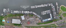
Attached is an example of a 2D image captured from 200' (hundreds of photos) captured with EVO II using Explorer missions, then processed with ODM. From a video standpoint, there are some where you can fly fast and dynamic like with FPV, for others, its flying slow, depends on what you are capturing.

Good luck.
 

Attachments

  • MarinaEveODM_081422smlawaw.png
    MarinaEveODM_081422smlawaw.png
    1.3 MB · Views: 5
  • Love
Reactions: AussieCate

Latest threads

Members online

Forum statistics

Threads
11,280
Messages
102,953
Members
9,878
Latest member
Elio-Italy