Welcome, Autel Pilots!
Join our free Autel drone community today!
Join Us

Autel Robotics EVO II PRO RTK V3 connecting to Topcon, Trimble, and NTRIP

Manny58200

Member
Joined
Apr 27, 2023
Messages
9
Reaction score
2
Age
42
Hi everyone. I'm new to online forums. I just bought an Autel Robotics EVO II PRO RTK V3 and would like the ability to connect to NTRIP and a local base obviusly at different times. We own almost every Topcon unit available (GR3, GR5, HyperV, MR2, HyperM, and HR) and for Trimble we have sps986 and sps855. Does anyone have a detailed list of instructions on how to connect this drone to any of the units listed? We also run UHF radios. Does this unit run a 915 SS radio. If so no biggy I have a Radio I can connect to any of these unit and broadcast whatever is needed. I did sent this to support and received a yes answer....literally just a yes....
 
  • Like
Reactions: altangerel
The Evo connects via standard NTRIP protocol over WiFi. You need an NTRIP provider, or broadcast NTRIP from your gnss receiver. Most use Emlid receivers as they have been developed with drone connectivity in mind. But if your receivers can broadcast NTRIP in some manner then they should work fine.

 
  • Like
Reactions: Detritalgeo
Thanks

So I'm used to UHF radios and SS915 radios. How does this equipment work in regards to the signals. Does the smart controller connect to the internet through a hotspot or mifi and then connects through its onboard radio via SS915 to the drone? So the drone doesnt need connectivity to the internet directly through a sim card? How does the base (RS2+) come into play? Does that unit connect directly to the drone through the onboard SS915 radio?


other words
NTRIP
wifi hotspot internet to smart controller to drone through SS915 radio for NTRIP

Local base
no internet needed base connects directly to the drone through SS915 setup completely by the smart controller.
Thanks for the information by the way. This is super helpful
 
You will only be able to achieve RTK when the survey is within wireless data coverage (Wi-Fi or 4G or starlink in remote locations). There is no provision to broadcast using UHF to the RC that operates the drone.

The controller and the base will need to be connected to Internet sothe NTRIP will function and in theory the base and controller can use a single cell phone hotspot if the base is close enough. The RS2 has a SIM card slot for independent data connectivity if needed.

Outside of wireless data coverage you will need to apply a PPK strategy or keep a starting system with you... although not certain starting has the low latency needed?
 
So I'm used to UHF radios and SS915 radios. How does this equipment work in regards to the signals. Does the smart controller connect to the internet through a hotspot or mifi and then connects through its onboard radio via SS915 to the drone?

This is some overlap in what @Detritalgeo mentioned above.

You connect the controller of the drone to a hotspot. There is no other external device contact to the controller, or the drone except for wifi/hotspot. The controller (via the Autel Explorer app) relays RTK communication to the drone. There is no way to interact with either the controller or the drone using radio, wifi only.

You need a NTRIP service that can be reached via a data connection on a hotspot. The drone controller will connect to the hotspot that is connected to the internet and receive corrections which it will transmit to the drone.

If no NTRIP service is available, or no data connection available, you can use an on site gnss receiver, e.g. the RS2+, and set it up on a known monument and the RS2+ has the ability to then broadcast NTRIP corrections to the Controller that is on the same wifi network as the gnss receiver. The RS2+ does not need a data connection for this to work. It can all be done on a local network.

If you don't have a known monument on site, you can still PPK your drone image positions later with a CORS log file if one is available. You can also use the strategy to record a point on site, and send RTK corrections to the controller just the same as above. And then afterward, you use a PPP service (e.g. OPUS) to first establish the recorded base point, and then use that established point to PPK the image set. PPP would require a decent amount of observation time.

If the receivers you have do not have the ability to broadcast NTRIP corrections over a data connection, then your options are a NTRIP service that you can reach by a data connection, or a PPK workflow using a CORS log. Or picking up an RS2+.
This is the way
 
  • Like
Reactions: DroneRat
One caveat that I would add to all of this that has not been mentioned by @Detritalgeo. You will NOT be able to use a Starlink system with the RS2+ as a Wi-Fi hotspot when connecting the drone to the RS2 for corrections. There is an IP address conflict. Starlink assigns and IP address that cannot be changed or manipulated. If your Starlink assigned IP address is a 192.168.1.xx, it will conflict with the IP address of the drone via smart controller connection and will not allow the drone to receive NTRIP corrections via the RS2+ Local NTRIP output. It is a known issue with the V3 firmware and the engineers are working on a solution in the next firmware update to be released, as I was told, late this year.

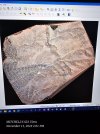
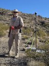
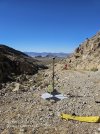
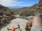
I recently finished a very large mining project out in the open desert and it was a nightmare to complete! I had one of my RTK V3 crash due to a bad battery cell, which AUTEL kindly repaired under warranty, but due to project timelines and sending the drone back and forth to them for repairs I purchased an additional V3 Enterprise to continue flying. There were extremely narrow valleys with extreme elevation changes within a very short distance on either side. In some cases up to a 45° incline. From the bottom of the valley floor, to the top of the ridges that have the massive inclines, was approximately a 950 ft average, so there were some places on the properties that I could only achieve photos between 700 to 900 ft. I was not able to achieve a constant RTK fix one the drone due to the location (It was seeing the satellites but just not shaking hands) so I laid 11 different control points with the RS2+ and although they were approximately 36 to 48 inch markings they were a nightmare to get entered into PIX4D MATIC due to the extreme pixelation from the elevation in some locations. There are some attachments of the pictures of the project site and some screenshots from the drone crash.


Here is some of that email correspondence I had with Auel regarding the Starlink.


Good morning Mitchell,

After a lot of testing and trying to recreate the issue, they found that the IP address is currently conflicting with the V3 aircraft's IP address which is the primary reason you could not connect.

As a temporary solution, you can change the wifi source to and address other than 192.168.1.XX. Please try to switch to 192.168.0.XX.

The engineer also asked if you are using a wifi source named Starlink 1, he asks if you can modify that IP address to 192.168.0.XX. He is saying once this adjustment is made, it should resolve the issue.

Our research and development team will address the IP issue in the next software update but this should be the workaround in the interim.


Here is my reply and again their final reply.


So after researching, I am not able to manipulate the Starlink IP address.
Unfortunately, I am unable to use any other Wi-Fi source. The mining site is out in the open desert and there is no cell phone signal whatsoever. The emlid RS2+ has a sim card, but cannot pickup any signal. That is why I am using the starlink. The rtk module on the aircraft will not fix, that is why I was trying to connect to the RS2+ for a fix over a know marker on site.


Hello Mitchell,

Our engineers are looking into this currently. In the interim, they offered a few solutions:

  • Contact Starlink and request to change the IP address to something other than 192.168.1.XX, as long as it doesn't start with 1.
  • If your goal is to "FIX" the drone, there's no need to use the Correction inputin the Emlid App. The correction input is meant for "FIX" the base station.
    • Use Reach's hotspot instead of connecting to other Wi-Fi networks to link with the RC.
    • There are three videos demonstrating how to do this; please refer to the videos.
  • If the you want to "FIX" the base station to obtain accurate location coordinates, we should split the process into two steps:
  • First, you can use the Starlink internet to apply the correction input to "FIX" the base station and record those coordinates.
    • Then, they can use the second solution mentioned above to "FIX" the drone.

Again I did contact Starlink and you are pretty much stuck with IP address they assigned to your unit.


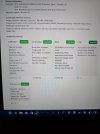
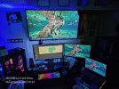
I finally ended up processing the data (6004 pictures for the largest property) over a 4-day period in PIX4D Matic and then adding the contour lines in PIX4Dsurvey and then importing the Orthomosaic with the contour lline DFX file as an overlay in QGIS and resizing to architectural D format for the client.
I was extremely surprised at the long processing time. I have two different computers that I used, which I consider to be high-end machines. My desktop workstation which is a Ryzen 5950X with 128 GB of DDR4 3200 and 2x 2TB PCIE 4 NVME m.2 SSDs with a RTX 4070 TI.
My other computer is an I-9 13980 HX with 64 GB of DDR5 at 5600 with a RTX 4080 and 2x 2TB PCIE 5 NVME m. 2 SSDs.

Oddly my I-9 13980 errored out several times on the processing at various different stages. ( And I am aware of the PIX4D - Microsoft OneDrive incompatibility issue) so I finally ended up using my desktop which ran and completed processing without any error on the 1st attempt.
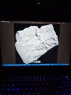
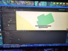
Attached are a couple of screenshots of the final outcome.

I share this in hopes that if any one of you have the same type of project or issues you will have this knowledge to work with. That is why I'm so very grateful for this form and all of the members that participate. Thank you to all of you!
 

Attachments

  • 20231111_140129.jpg
    20231111_140129.jpg
    2.7 MB · Views: 10
  • IMG_20231110_184637_01.jpg
    IMG_20231110_184637_01.jpg
    3.1 MB · Views: 9
  • IMG_20231110_184420_01.jpg
    IMG_20231110_184420_01.jpg
    1.2 MB · Views: 9
  • 20231108_185132.jpg
    20231108_185132.jpg
    3 MB · Views: 8
  • IMG_20231108_191209.jpg
    IMG_20231108_191209.jpg
    4.1 MB · Views: 9
  • IMG_20231031_151641.jpg
    IMG_20231031_151641.jpg
    1.7 MB · Views: 9
  • 20231031_111441.jpg
    20231031_111441.jpg
    3.9 MB · Views: 9
  • 20230927_143332.jpg
    20230927_143332.jpg
    4.7 MB · Views: 7
  • 20230927_132255.jpg
    20230927_132255.jpg
    3.2 MB · Views: 8
  • Like
Reactions: EBERLS

Latest threads

Members online

No members online now.

Forum statistics

Threads
11,287
Messages
103,008
Members
9,897
Latest member
SycamoreGroves