- Joined
- May 9, 2021
- Messages
- 293
- Reaction score
- 153
- Age
- 68
- Location
- Kingwood, TX
- Website
- www.raptoraerialservices.com
I wanted to share my experience flying a relatively large survey.
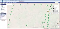
Last week I completed a 172 acres drone survey over Fort McKavett about 20 miles west of Menard, TX. I used an Autel Evo II Enterprise Pro 6K RTK drone. Given the size of the survey, the way that Autel Explorer handles battery changes, and the windy conditions, I designed the survey into 5 overlapping sections with 3 different launch points (HPs). This also helped keep the maximum horizontal distance from the launch point to generally less than 1500 ft..
I planned on 10 GCPs but could only use 9 due to access limitations to one location. The GCPs were surveyed in using an EOS Arrow Gold GNSS RTK receiver. The closest TopNet Live (my NTRIP subscription service) base station was about 144KM away. I was able to connect to the base station and get RTK corrections. Even though I had the RTK module attached to the drone, I had the service turned off in the Explorer App.
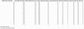
Survey Specs:
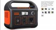
Finally, the Smart Controller burns through it's charge relatively quickly under constant use. I plugged the Smart Controller into my Jackery Portable Power Station Explorer 240 to keep the Smart Controller charged. This seemed to work pretty well. I didn't notice the Smart Controller getting too hot (only slightly warm).
Last week I completed a 172 acres drone survey over Fort McKavett about 20 miles west of Menard, TX. I used an Autel Evo II Enterprise Pro 6K RTK drone. Given the size of the survey, the way that Autel Explorer handles battery changes, and the windy conditions, I designed the survey into 5 overlapping sections with 3 different launch points (HPs). This also helped keep the maximum horizontal distance from the launch point to generally less than 1500 ft..
I planned on 10 GCPs but could only use 9 due to access limitations to one location. The GCPs were surveyed in using an EOS Arrow Gold GNSS RTK receiver. The closest TopNet Live (my NTRIP subscription service) base station was about 144KM away. I was able to connect to the base station and get RTK corrections. Even though I had the RTK module attached to the drone, I had the service turned off in the Explorer App.
Survey Specs:
- ~172-acres coverage area
- 5 overlapping sections
- 9 GCPs
- 250' AGL
- 80%/80% Overlap
- 13 MPG (I originally intended on flying at 15 mph but I confirmed I flew each section at 13 mph)
- GSD 0.5 in/px
- Average Direction 161
- Max Direction 186
- Min Direction 133
- Average Wind 11
- Max Wind 17
- Min Wind 4
- Average Gust 16
- Max Gust 26
- Min Gust 8
Finally, the Smart Controller burns through it's charge relatively quickly under constant use. I plugged the Smart Controller into my Jackery Portable Power Station Explorer 240 to keep the Smart Controller charged. This seemed to work pretty well. I didn't notice the Smart Controller getting too hot (only slightly warm).